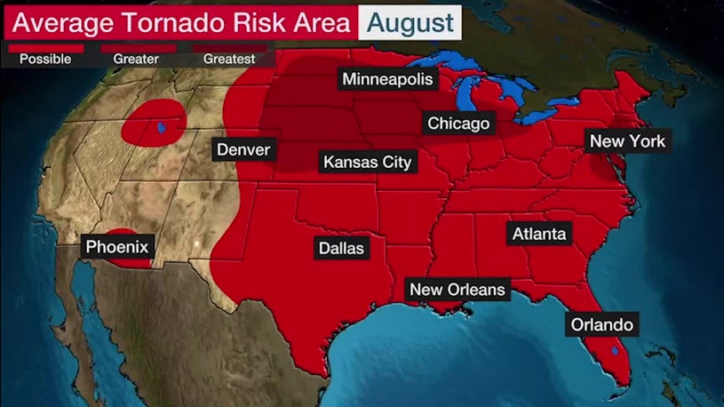
- Tornado risk persists in late summer, especially in parts of the northern tier.
- Derechos can still result in widespread destruction.
- The Southwest monsoon lasts through September and brings several hazards.
- Flash flooding concerns remain high through late summer.
- The peak of hurricane season occurs in late summer.
Severe weather, including tornadoes, derechos and flash flooding, can result in dangerous conditions through late summer in parts of the United States.
Below, we take a closer look at what types of severe weather can create havoc in the Lower 48 as the warm months come to a close.
Tornado Risk in August
The average number of tornadoes decreases in August compared to the active spring and early summer months. However, tornadoes are still a threat through late summer.
Tornadoes can occur almost anywhere during the warmest months, but locations at a higher tornado risk are farther north than in the spring due to the jet stream being closer to the Canadian border.
The areas at highest risk for tornadoes in August extend from the Northern and Central Plains into the southern Great Lakes. There is also a higher risk area from portions of the mid-Atlantic into southwestern New England.
Many August tornadoes develop due to tropical cyclones, and there is also a slight uptick in the Southwest because of the monsoon season.
Average tornado risk in August, based on data from 1991 through 2015.
Derechos Can Develop, Too
Derechos are large clusters of thunderstorms that cause widespread destruction to trees, power lines and sometimes structures.
They are most common in late spring and summer in the U.S., with a peak from May through July. However, they do occur in August and are still very damaging, as seen by the derecho that raced 770 miles in 14 hours across the Midwest early this week.
(MORE: Midwest Derecho Causes Widespread Damage)
Annual Derecho Occurrence in the United States
(Data: NOAA's Storm Prediction Center)Derecho comes from the Spanish word for "straight" and these windstorms leave wide, long areas of straight-line wind damage. The winds can be as strong as 60 to 100 mph or higher in extreme cases. Damage from derechos can be tens of miles wide and hundreds of miles long.
Derechos can occur in many states east of the Rockies, but they are most common in parts of the Plains, Midwest and South.
Where Derechos Are Most Common
(Source: NOAA's Storm Prediction Center)Southwest Monsoon Hazards
The Southwest monsoon is typically active from June 15 through Sept. 30. A monsoon is a change in seasonal winds, and in this case, the shift in winds results in an increase in thunderstorm activity in the region.
This moisture increase reduces the risk of wildfires and brings much-needed rain for reservoir replenishment and vegetation. The monsoon also brings relief from the scorching heat.
The monsoon pattern brings several hazards as well, including heavy rain, flash flooding, lightning, downburst winds and dust storms. Conditions can change rapidly, and if you are outdoors in the Southwest during the monsoon season, it is important to be aware of weather conditions, have ways to get weather warnings and be able to get to a safe place quickly.
This year, however, the monsoon has been generally missing so far and has led to growing drought and record heat in the Southwest.
Southwest Monsoon Concerns
Flash Flood Dangers
The frequency of flash flooding in the U.S. peaks from late spring through summer because several weather factors converge. These factors include: an atmosphere that is warmer and more humid in areas east of the Rockies; the Southwest monsoon is active; and hurricanes can bring tropical moisture.
A flash flood is usually caused by heavy or excessive rainfall in a short period of time, generally less than six hours. Flash flooding can occur within minutes of heavy rainfall.
The average number of annual deaths from flooding in the past 10 years is 104. That makes flooding, on average, more deadly than hurricanes and tornadoes. Most flash flood fatalities occur while driving.
Take flash flood warnings seriously and never drive into floodwaters of unknown depth. It can be difficult to judge how deep water is, and just six inches of water can cause loss of control and stalling of a vehicle.
Flash Flood Factors in Late Spring and Summer
Atlantic Hurricane Season Peaks
The Atlantic hurricane season officially runs from June through November, but the peak arrives in late summer. This is the time of year when conditions become most favorable for hurricanes, and it is often when the most powerful and destructive hurricanes occur.
When tropical cyclones track close to land, numerous impacts, including heavy rain, flooding, strong winds, tornadoes and rip currents, can result.
Slow-moving tropical systems can bring prolific amounts of rainfall, like hurricanes Harvey in 2017 and Florence in 2018.
Hurricanes can also spawn tornadoes. Hurricane Ivan in 2004 resulted in the most tornadoes on record: 120 over nine states.
(MORE: The Five Atlantic Hurricanes That Produced the Most Tornadoes)
The typical frequency of named storms (in red) and hurricanes (in white) by month in the Atlantic Basin.
The Weather Company’s primary journalistic mission is to report on breaking weather news, the environment and the importance of science to our lives. This story does not necessarily represent the position of our parent company, IBM.
"occur" - Google News
August 12, 2020 at 03:24AM
https://ift.tt/30KYCbg
Tornadoes, Derechos and Flash Flooding: Types of Severe Weather to Watch for in Late Summer - The Weather Channel
"occur" - Google News
https://ift.tt/2UoDqVw
https://ift.tt/2Wq6qvt
Bagikan Berita Ini


0 Response to "Tornadoes, Derechos and Flash Flooding: Types of Severe Weather to Watch for in Late Summer - The Weather Channel"
Post a Comment